
Urgent: Oregon’s Weather Turns Treacherous with Incoming Storms
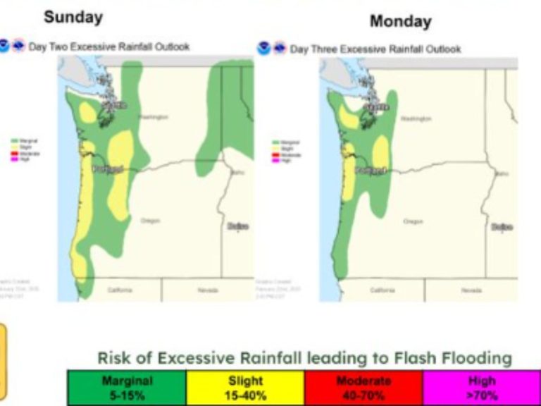
Residents across Oregon should prepare for a significant weather event today, Monday, February 24, 2025, as meteorologists forecast heavy rain and strong winds impacting various regions. The National Weather Service (NWS) has issued multiple advisories in anticipation of the storm’s effects.
Portland and Surrounding Areas
In Portland, the day began with cloudy skies and temperatures around 45°F (7°C). As the system moves in, expect increasingly windy conditions accompanied by substantial rainfall. The NWS warns that these strong winds may lead to localized damage, power outages, and hazardous travel conditions.
Detailed Forecast for Portland:
- Monday, Feb. 24: Rain and wind intensifying throughout the day. High near 55°F (13°C); low around 47°F (8°C).
- Tuesday, Feb. 25: Morning showers with variable cloudiness later. High of 58°F (14°C); low of 38°F (3°C).
- Wednesday, Feb. 26: Mild with a mix of clouds and sun. High reaching 64°F (18°C); low at 40°F (4°C).
Salem and the Willamette Valley
The Willamette Valley, including Salem, is also under alert. Residents should prepare for increasingly windy conditions with rain, as strong winds could cause localized damage, power outages, and dangerous travel.
Salem’s Forecast Highlights:
- Monday, Feb. 24: Wind and rain intensifying. High of 60°F (16°C); low at 49°F (9°C).
- Tuesday, Feb. 25: Breezy morning with showers; variable cloudiness later. High near 60°F (16°C); low around 37°F (3°C).
- Wednesday, Feb. 26: Clouds giving way to clearer skies. High of 60°F (16°C); low at 39°F (4°C).
Eugene and Surrounding Regions
Further south in Eugene, similar conditions are expected. The NWS advises residents to remain cautious, as the combination of rain and wind may lead to challenging travel and potential power disruptions.
Eugene’s Weather Outlook:
- Monday, Feb. 24: Rain becoming heavy with increasing winds. High near 58°F (15°C); low around 45°F (7°C).
- Tuesday, Feb. 25: Morning showers transitioning to cloudy skies. High of 61°F (16°C); low at 32°F (0°C).
- Wednesday, Feb. 26: Mild with intervals of clouds and sunshine. High reaching 64°F (18°C); low at 38°F (4°C).
Central Oregon: Bend Area
In Central Oregon, particularly around Bend, a High Wind Warning is in effect from 11:00 AM PST today until 4:00 PM PST Tuesday. Residents should prepare for southwest winds ranging from 25 to 35 mph, with gusts between 45 to 60 mph. These conditions may result in damaging winds capable of downing trees and power lines, leading to widespread power outages. Travel, especially for high-profile vehicles, could be difficult.
Bend’s Forecast Snapshot:
- Monday, Feb. 24: Mostly cloudy and windy; rain expected in the afternoon. High of 53°F (12°C); low at 35°F (2°C).
- Tuesday, Feb. 25: Breezy morning with a mix of clouds and sun later. High near 52°F (11°C); low around 27°F (-3°C).
- Wednesday, Feb. 26: Warmer with sun and high clouds. High reaching 63°F (17°C); low at 31°F (0°C).
Safety Precautions
Residents across Oregon are urged to:
- Secure Outdoor Items: High winds can turn loose objects into projectiles.
- Prepare for Power Outages: Have flashlights, batteries, and other essentials ready.
- Exercise Caution While Driving: Be mindful of slippery roads and reduced visibility.
- Stay Informed: Monitor local news and official weather updates for the latest information.